Map by TWCarlson / Wikimedia Commons
The British Isles can be confusing territory, both literally and figuratively. This clever Euler diagram breaks down the overlapping relationships between different geographical and political entities in ways that might surprise you.
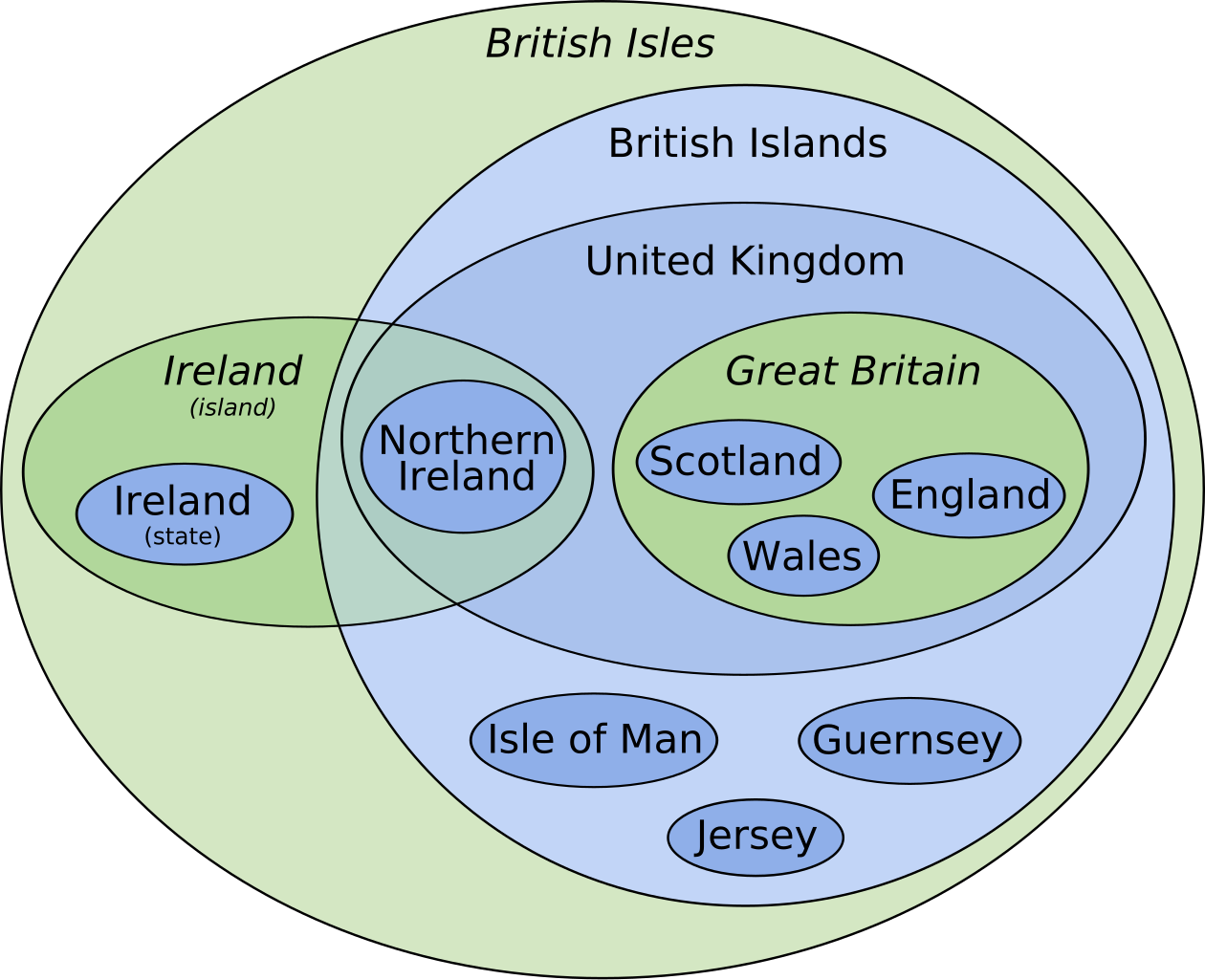
The outermost green circle represents the British Isles, a purely geographical term describing the entire archipelago. This includes everything: Great Britain, Ireland, and all the smaller surrounding islands.
It’s important to note that “British Isles” is sometimes considered a controversial term in Ireland, where many prefer “Britain and Ireland” or “these islands.”
The Political Puzzle of the British Islands
Within the British Isles sits the blue area labeled “British Islands,” which represents a specific legal and political concept. This includes the United Kingdom plus the Crown Dependencies (Isle of Man, Jersey, and Guernsey), but notably excludes the Republic of Ireland.
The distinction matters more than you might think. While the Crown Dependencies aren’t technically part of the UK, they fall under British sovereignty and use British passports. They maintain their own governments and tax systems, creating a unique constitutional arrangement that has persisted for centuries.
Breaking Down Great Britain and Ireland
Great Britain, shown in green within the diagram, is the largest island and contains three countries: England, Scotland, and Wales. These three, plus Northern Ireland, form the United Kingdom. Notice how Northern Ireland sits separately from Great Britain but within the UK boundary.
The island of Ireland is split politically. The Republic of Ireland operates as an independent nation and EU member, while Northern Ireland remains part of the UK. This division, established in 1921, continues to influence politics and identity across both parts of the island.
Crown Dependencies: The Forgotten Territories
Those smaller blue circles representing the Isle of Man, Jersey, and Guernsey often get overlooked in discussions about British geography. These Crown Dependencies enjoy remarkable autonomy.
The Isle of Man has the world’s oldest continuous parliament, while Jersey and Guernsey maintain their own currencies alongside British pounds.
These territories benefit from unique constitutional positions that allow them to remain outside the EU (even when the UK was a member) while maintaining special relationships with both Britain and Europe.
Why This Matters Today
Understanding these relationships helps explain everything from passport controls to tax havens to Brexit complications. The Irish border became a central Brexit issue precisely because of these overlapping identities and jurisdictions.
For travelers, these distinctions can mean different entry requirements, currencies, and even mobile phone roaming charges. For politicians and diplomats, they represent centuries of complex constitutional evolution.
This diagram elegantly illustrates how geography, history, and politics intertwine to create the intricate web of relationships that define the British Isles today.
Help us out by sharing this map: