Map from Wikimedia Commons
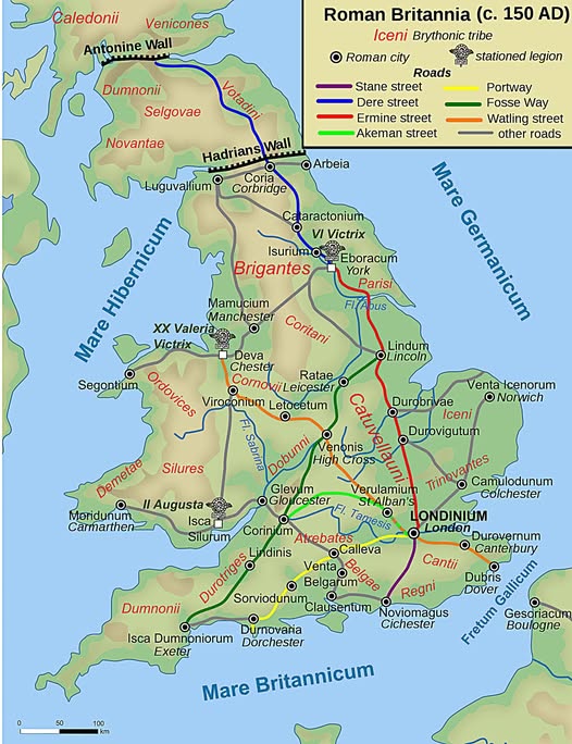
Around 150 AD, Roman Britain was one of the most fascinating frontiers in the ancient world. The map above captures this remarkable moment: a conquered island being stitched together by stone roads, military muscle, and urban ambition.
If you have ever driven the A5 or the A1 in England, congratulations; you are basically following Roman engineering that is nearly 2,000 years old.
The Roads That Built an Empire
The Romans were obsessive road builders, and Britain was no exception. The map shows several of their greatest hits.
Watling Street (orange) sliced diagonally from the southeast coast up through Londinium (London) toward the northwest. Ermine Street (red) ran almost perfectly north to south, connecting London to Lincoln and York. The Fosse Way cut a remarkably straight diagonal line across the middle of the country, linking Exeter to Lincoln.
These were not dirt tracks. They were engineered highways with drainage, cambered surfaces, and military waypoints. Goods, soldiers, and ideas all flowed along them.
Londinium: The Hub of Everything
Even in 150 AD, London was already the center of gravity. Londinium sat at the intersection of major roads and served as the commercial and administrative capital of the province.
From here, Roman authority radiated outward to towns like Camulodunum (Colchester), Verulamium (St Albans), and Lindum (Lincoln).
The Tribes Who Never Quite Left
One of the most striking features of this map is how the native British tribes are still named and present.
The Brigantes occupied most of northern England. The Iceni, famous for producing the warrior queen Boudica, held the east. The Silures and Ordovices dominated Wales.
Rome conquered these peoples militarily, but tribal identities persisted beneath the Roman veneer for generations.
Two Walls, Two Problems
Rome drew hard lines in the north. Hadrian’s Wall, completed around 122 AD, stretched across northern England and marked the practical limit of Roman control.
Further north still, the Antonine Wall pushed into modern Scotland for a time, though Rome eventually pulled back to Hadrian’s more defensible line.
Everything above these walls belonged to the unconquered Caledonians and other peoples Rome never truly subdued.
Why This Map Still Matters
Modern Britain is layered on top of Roman Britain in ways most people never notice. Dozens of English cities end in “chester” or “caster,” both derived from the Latin word “castra,” meaning fort. The road network shaped settlement patterns that persist to this day. Roman Britain was not just an occupation; it was a foundational chapter in the story of the island.
Next time you sit in traffic on a motorway, spare a thought for the Roman legionary who probably helped lay down the route two millennia ago.
Help us out by sharing this map: