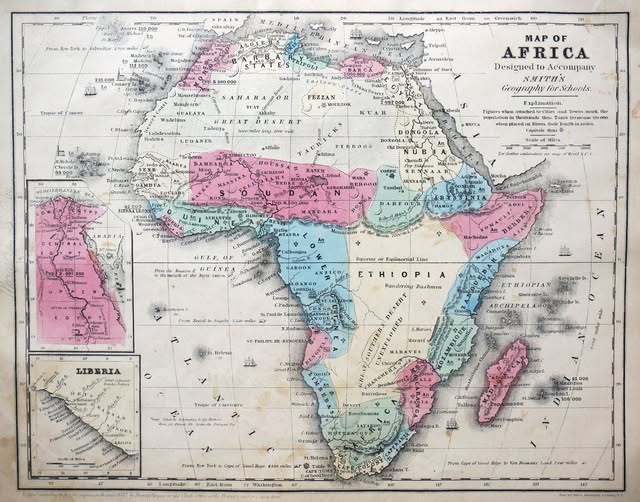
Map from Smith’s Geography for Schools
This gorgeous hand-colored map of Africa comes straight from Smith’s Geography for Schools, a popular American educational atlas published in the mid-1800s.
At first glance, it looks like a colorful curiosity. Look closer, and it becomes a window into a world that was rapidly changing, and not always for the better.
What You Are Actually Looking At
The map is a school resource, designed to help American students understand world geography at a time when much of Africa’s interior remained genuinely unmapped by Western cartographers.
Notice how the detail thickens around the coastlines and thins dramatically as you move inland. Large interior regions are labeled with broad, sweeping names like Great Desert, Sudan, and Ethiopia, which at the time referred to vast, loosely defined territories rather than the nations we know today.
The color coding groups regions by political or cultural association, a common technique in 19th-century cartography. Pink and blue zones reflect the European and North African powers that were beginning to cast long shadows over the continent, even before the full scramble for Africa accelerated after 1880.
That Inset of Liberia
The small inset map in the bottom left highlights Liberia, and that detail is telling. Liberia was founded in 1822 as a settlement for freed American slaves, backed by the American Colonization Society.
Its prominent placement on an American school map was no accident. It was a point of genuine national interest and moral conversation in pre-Civil War America.
The Names That No Longer Exist
Part of what makes old maps so compelling is the ghost geography they carry. Regions labeled here like Nubia, Darfoor, and Senegambia have either vanished from modern atlases or been redrawn entirely.
The Ethiopian Archipelago shown off the east coast is what we now call the islands of the western Indian Ocean, including the Comoros and the Seychelles.
Why Maps Like This Still Matter
Old maps are not just pretty wall art (though they absolutely are that too). They are primary sources. They tell you what people believed, what they feared, what they wanted to claim, and what they simply did not know yet. This one captures Africa at an extraordinary hinge point in history, just before colonial borders were carved across the continent with little regard for the peoples already living there.
If you ever spot one of these Smith’s Geography maps at an estate sale or antique market, do not walk past it. You are looking at history rendered in ink and color, one lesson at a time.
Help us out by sharing this map: