Map found on Reddit
Ever wondered just how long the US-Mexico border really is?
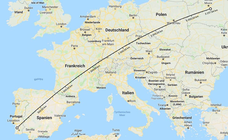
Most Americans have a vague sense that it’s long, but the true scale doesn’t hit home until you visualize it differently. When you stretch that border across Europe, from Portugal to beyond Poland, the results are eye-opening.
The border between the United States and Mexico spans roughly 1,954 miles in a straight line. That’s not counting the twists and turns of the Rio Grande or the various geographic features that make up the actual boundary.
When you overlay this distance on a map of Europe, it reaches from the Atlantic coast of Portugal all the way past Warsaw, Poland, cutting through multiple countries and time zones.
A Continental Journey
Imagine driving from Lisbon to Warsaw. You’d pass through Portugal, Spain, France, Germany, the Czech Republic, and finally into Poland.
That’s six countries, countless cultures, dozens of languages, and a journey that would take you from Atlantic seafood to Central European pierogis. This is the same distance that separates San Diego from Brownsville, two cities within the same country.
Why This Matters
This comparison isn’t just a fun geographic exercise. It highlights something important about the United States that we often take for granted: its sheer size.
While Europeans might cross three borders in a day trip, Americans can drive for 30 hours and never leave their own country.
Understanding this scale also provides context for border management discussions. Securing or monitoring a distance equivalent to half the width of Europe is no small logistical feat.
Whether you’re talking about infrastructure, patrol routes, or environmental impact, the scope of the challenge becomes clearer when you visualize it this way.
The Power of Visual Comparison
Maps can be deceiving, especially when we’re used to seeing our own country front and center. Americans often underestimate how large their nation is compared to European countries, while Europeans might not grasp the distances involved in American geography. This simple overlay bridges that gap.
Next time someone discusses border policy or you’re planning a cross-country road trip, remember this image. The distance from Portugal to Poland isn’t just numbers on a page. It’s a tangible journey through diverse landscapes, climates, and cultures. And that’s exactly what the US-Mexico border represents, too, just contained within two nations instead of six.
Help us out by sharing this map: