Map by Alexander Altenhof / Wikimedia Commons
Looking at Europe in 1812 is like witnessing the moment before everything changed. Napoleon Bonaparte had transformed the continent into his personal chessboard, and France’s influence stretched from Spain to the borders of Russia.
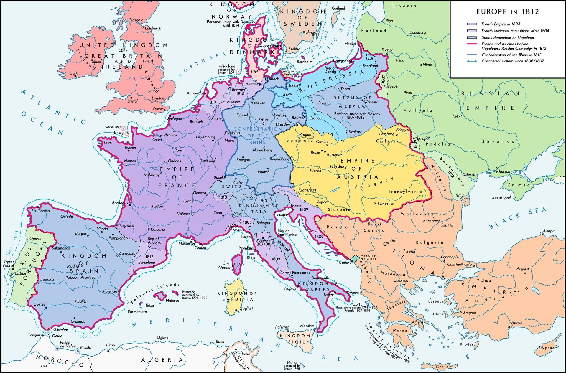
The map shows us something remarkable: nearly half of Europe was either directly controlled by France, allied with it, or dependent on Napoleon’s goodwill.
The purple territories reveal the extent of the French Empire proper, while the lighter shades show satellite kingdoms and states that danced to Napoleon’s tune. His relatives sat on thrones across Europe. His brother Joseph ruled Spain, while another brother, Louis, governed Holland.
This wasn’t just military conquest; it was family business on a continental scale.
The Continental System at Work
That thick pink line snaking around the map represents something fascinating: the Continental System.
Napoleon’s ambitious attempt to economically strangle Britain by closing European ports to British trade. It was an early form of economic warfare that forced nearly every coastal nation to choose sides. Some historians argue that this overreach planted the seeds of Napoleon’s eventual downfall.
The system required constant enforcement and created resentment among nations that depended on trade with Britain. Even Napoleon’s allies found ways to smuggle British goods, showing that economic reality often trumps political decrees.
Russia: The Sleeping Giant
Notice how the Russian Empire sprawls across the eastern portion of the map in pale green. In 1812, Napoleon made his fateful decision to invade Russia, frustrated by Tsar Alexander’s refusal to fully comply with the Continental System. This campaign, barely beginning when this map was made, would prove catastrophic.
The sheer size of Russia on this map hints at the challenge Napoleon faced. Distance, winter, and scorched earth tactics would decimate his Grande Armée. Of the roughly 600,000 soldiers who marched into Russia, fewer than 100,000 would return.
The Holdouts
Britain stands alone in salmon pink, unconquered and defiant. Protected by the English Channel and the Royal Navy, it remained the organizing force behind various coalitions against Napoleon.
The Ottoman Empire in the southeast and Sweden in the north also maintained their independence, though Sweden’s position was precarious.
Why This Moment Matters
This map captures an empire at its zenith and the moment before its collapse. Within three years, Napoleon would be exiled to Elba, briefly return for the Hundred Days, lose at Waterloo, and end his days on remote Saint Helena. The Europe shown here would be completely reorganized at the Congress of Vienna.
Understanding this map helps us grasp how quickly geopolitical fortunes can shift and how even the most dominant powers overextend themselves. Napoleon controlled more of Europe than perhaps any single ruler since the Romans, yet it all unraveled in just a few years.
Help us out by sharing this map: