Map found on Reddit
Most of us think of the coastline as a bragging right. “We have 60,000 km of coastline!” sounds impressive until you realize that a giant country saying that is a bit like a mansion owner boasting about one nice window.
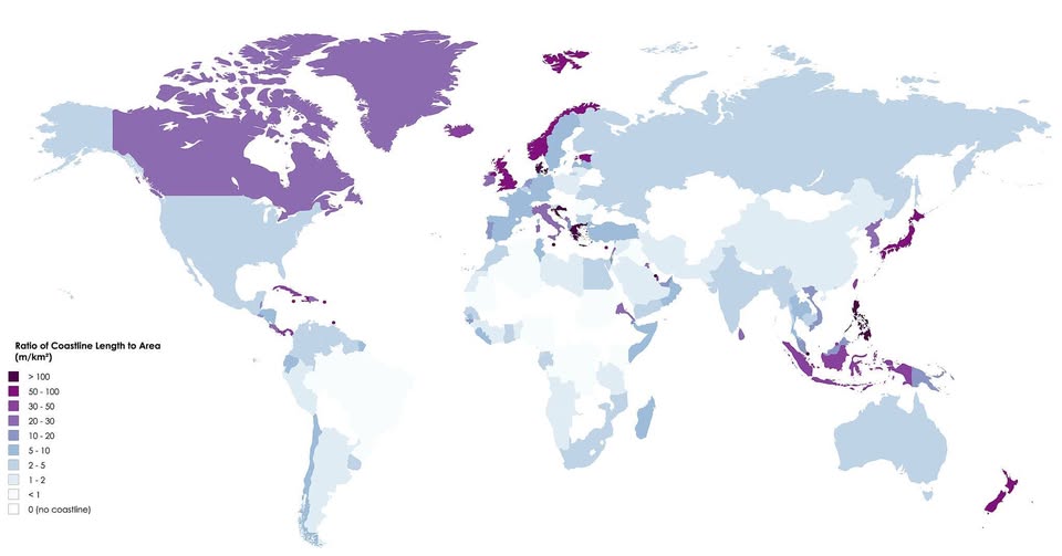
What actually matters is how much coast you have relative to your size, and this map flips the usual narrative on its head.
The Metric That Changes Everything
The map shows each country’s ratio of coastline length to land area, measured in metres of coast per square kilometer of land. The deeper the purple, the more “coastal” a country truly is in a meaningful sense.
Countries shaded dark are essentially wrapped-in-ocean. Lightly shaded ones are mostly interior.
The Surprising Winners
Norway blazes dark purple, and for good reason. Its famously jagged fjords create an almost absurd amount of coastline packed into a relatively modest landmass. The same logic applies to Greece, the Philippines, and Indonesia: all archipelagos or heavily indented coastlines that punch way above their weight.
Canada looks impressive in deep purple, too, but that’s partly a function of its genuinely enormous coastline (the longest in the world in absolute terms) combined with a land area that, while vast, still yields a high ratio.
Small island nations – many too tiny to see clearly on this map – would score off the charts if labelled individually. Places like Tuvalu or the Maldives are essentially just coastline with a little land attached.
The Quiet Giants
Russia, Brazil, Australia, and the United States (minus Alaska) sit in the lighter shades. They have coast, sure, but their sheer continental bulk dilutes the ratio dramatically. Most of their territory is hundreds of kilometres from any ocean.
Landlocked countries (shown in white) score zero by definition. Central Asia, much of Africa’s interior, and countries like Bolivia and Hungary simply have no coastline to measure.
Why Does This Matter?
This ratio is more than a geographical curiosity. Coastal access shapes economies, trade, fishing industries, tourism, and even climate.
Countries with high ratios tend to have deeply maritime cultures; think Norway’s seafaring history or the Philippines’ fishing communities. A high coastline-to-area ratio also means more exposure to storms, sea level rise, and the logistical challenge of defending long borders.
The Takeaway
The world looks very different when you stop measuring coastlines in raw kilometers and start measuring them relative to the land they belong to. The “most coastal” countries are often not the biggest ones; they’re the most intricate ones, the island chains and the fjord nations, where the sea is never far from your doorstep.
Next time someone tells you their country has a long coastline, ask them: long compared to what, exactly?
Help us out by sharing this map: